 |
|
EVALUATING
THE LAND
|
|
|
The first step in the planning process is to evaluate the current types of
habitat, wildlife residents, and plant life on your property. Finding out what plants and animals live on your land will help you understand their habitat needs and how you can better manage for those needs. Also, it is important to look at your surrounding
landscapes and determine how your land fits into the bigger picture. Your inventory will yield clues as to what degree of success you can expect to achieve, and it will provide information that is useful in working with your neighbors. Finally, the information you compile in this inventory will be useful in writing your overall management plan. Keeping a journal of information throughout the planning process will simplify your efforts. |
Before you begin, you may have broad ideas of what you want to do with your land. Evaluating your land enables you to make these ideas more concrete, or even find that they are not feasible. After this evaluation, you should be able to set goals that are appropriate for your land. For more information refer to the chapter on
Setting Goals and Considering Alternatives.
By taking such a broad initial view of your land and surrounding landscapes, you can begin to get a perspective of its suitability for attracting wildlife. It is also important to gain a historical perspective of the land's past uses. Do you have agricultural fields that have been tiled? Do you have forests that have been logged in recent memory? Was your grassland pastured some time ago, can you find out how long ago? Did farming practices over the years change the soil's
pH? The more information you find about your property, the more you will learn of its wildlife-producing history, suitability and potential. Ask these questions of longtime neighbors and former owners. Search the local library for historical information about farming practices, flooding incidents or area fires that might have involved your property. It is also helpful to obtain a pre-settlement map that will give you clues as to what habitat types were present before European settlement. See the chapter on
Presettlement/ Past Vegetation Types for more information.
Make a Habitat Inventory
Many of the chapters in this manual will help you understand the different types of habitat and what
species of wildlife use them. Try to assess the condition of the property and how it is being used. As you learn about your land's attractiveness to wildlife, begin to classify the types of habitat found there. What follows are the five broad kinds of Michigan habitats. The questions below may be useful in an initial evaluation of your land.
- Is your property largely farmland, grassland, woodland, wetland, brushland, or a combination of two or more types?
- What habitat surrounds your property?
- What type of soils do you have? Are they sand, clay, or muck? Wet or dry?
- Are there exotic species present? If so, what species?
Woodland
-
 What type of forest exists? Is it young, mature, or mixed? How large is it?Is it fragmented by trails or openings? What type of forest exists? Is it young, mature, or mixed? How large is it?Is it fragmented by trails or openings?
- Is the understory open or is there a lot of growth such as brush and
shrubs?
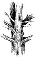
- Are there dead or decaying trees? How many? Where are they located? Are there stumps?
- Has the forest been logged or pastured, and, if so, how long ago?
- Is the stand even- or
uneven-aged?
Wetlands
- What type of wetland is present?
- Is there a stream present? If so, what is the stream's origin?
- Is the wetland permanent or temporary (seasonal)?
- Is the wetland isolated or part of a larger complex?
- Is there open water present?
- How large or small is the wetland?
- Has the wetland been altered by draining, grazing, or mowing?
- Do trees, brush/shrubs, cattails, grass, or sedges dominate the wetland?
- Are adjacent uplands being fertilized?
Grassland
- Is your grassland an old field, pasture, hayfield, or forest opening?
- Are there any remnant native plant species present?
- How much invasion is occurring from shrubs, trees, or other woody plants?
- Has your grassland been hayed, mowed, or used for pasture? How long ago?
- Do you mow the roadside ditches? If so, how often?
Farmland
- What is the recent crop history?
- What kinds of herbicides,
insecticides, or other chemicals were recently applied?
- Are there livestock present? How many?
- What type of farming operation (if any) is occurring? Is it small grain, row crop, dairy, or other livestock?
- Is it flat or rolling farmland?
- Is the farmland being cultivated right up to the fences?
- What type of irrigation practices are being used? Are the fields ditched or tiled?
- Are there areas of cropland that will not grow, or muddy places where equipment gets stuck? These areas may be former wetlands.
Brushland or Shrubland
- Are shrubs large or small, in clumps or individuals?
- Are they fruit producing?
- Can you determine the stage of succession (is it closer to the forest or grassland stage)?
- Do the plants growing there favor a wet or dry environment?
- What types of habitat surround the brushland?
- Are there fencerows or
hedgerows present?
| Example worksheet: |
| Area (Habitat Type): |
Grassland |
|
|
| Animal
species |
Plant species |
Invasive
plant species |
Practices
present
(logged, drained, tiled, etc.) |
| Quail |
Orchard grass |
Quack grass |
None |
| Goldfinch |
Timothy grass |
Sweet clover |
|
| Sparrow |
Smooth brome |
|
|
| Meadowlark |
|
|
|
| Rabbit |
|
|
|
| Pheasant |
|
|
|
| Red-winged blackbird |
|
|
|
| Deer mouse |
|
|
|
Make an Animal Inventory
Knowing what animals currently live on or around your property is a starting point for your animal inventory. If you are already familiar with your property, take time now to write down as many kinds of wildlife as you can recall.
 Separate them into categories such as mammals, birds, reptiles, and amphibians--even fish and insects if appropriate. Indicate where and when you have seen them. If you do not know the names, simply describe them, or sketch them if you can. Separate them into categories such as mammals, birds, reptiles, and amphibians--even fish and insects if appropriate. Indicate where and when you have seen them. If you do not know the names, simply describe them, or sketch them if you can.
If you're not familiar with your property, take walking tours as often as possible. Armed with a notebook and a good field guide, look and listen for animals. Try to sharpen your evidence-gathering skills. For example, a small, chipmunk-sized burrow or a large woodchuck den in the side of a hill are clues as to what lives there. Hoof or paw prints in the mud or snow are evidence of the presence of wildlife.
Brambles whose branches have been nipped could be the work of a rabbit or deer. The persistant smell of a skunk may let you know of this animal's presence. You may be surprised at all the wildlife that exist on your property, even if you never actually see them.
Become a wildlife detective and see how many of the following animal signs you can find. Add them to your animal inventory as you discover them.
- Young trees with bark rubbed off in autumn by a buck deer polishing his antlers.
- A large stick nest high in an oak tree, which may be home to a red-tailed hawk or great-horned owl. Similarly, a large leafy nest may indicate the presence of fox or gray squirrels.
- Holes in dead trees may be a home for a woodpecker or black-capped chickadee.
- Furry pellets, or hairballs, regurgitated by an owl.
- Runways through a field of grass made by small rodents.
- Black walnuts cracked in half by fox or gray squirrels.
- Pine cone "cobs" left behind by red squirrels.
- Porcupine droppings (they are orange) at the base of a tree.
- Hickory nuts nibbled on the edges by deer mice.
- A mud nest under a house or barn eave made by cliff swallows or barn swallows.
- Last year's bird nests.
- Dusting bowls made by pheasants used for delousing.
- Scattered feathers or fur from a predator's meal.
- Spider webs, or other such insect signs.
- An ant mound.
- A butterfly chrysalis or moth cocoon.
- The call of sandhill cranes, loons, or Canada geese in the distance.
- The trill of courting toads.
- Tracks or droppings created by mammals and birds.
Because not every animal will be visible on any given walking tour, be sure to periodically walk your property during different seasons and times of day. Keep notes on what you observe and when. Try to determine if the wildlife are feeding, seeking
shelter, building nests, or using your property for some other purpose. Your journal will help you to accurately describe your land and will become the basis for writing a wildlife management plan. The more you walk your land, the better you'll get to know it and its inhabitants.
Make a Plant Inventory
What grows on your property determines what wildlife will live there. While walking your land, begin to develop a list of existing plants along the way. Again, field guides to trees, shrubs, flowers, and grasses will be a big help. Sketch, describe, or photograph plants that you are unfamiliar with. As you read, check sources and ask questions, your experience and confidence will grow.
Management recommendations are often based on the predominant plant species in an area. Therefore, make observations about the predominant species that are present in each habitat type on your land. For example, is your forest
predominantly Beech/ Maple, or Oak/Hickory? Note if the species present are native or exotic. This helps you to determine the condition of your land. For example, if your grassland possesses species such as big bluestem, little bluestem, and switchgrass, it may be a remnant of a native
prairie. Note any species that you think may be rare. In addition to this, identify nuisance
weeds such as purple loosestrife, glossy buckthorn, autumn olive, honeysuckle, and others, and plan for their elimination.
Soils
Learning about the soils on your property will help you to know what may and may not grow there. Sandy, light soils, for example, allow water to drain readily. Therefore, they are usually low in
nutrients and tend to be more
acidic than other types. Heavy, clay soils consist of small, tightly packed soil particles. Rich in nutrients, they have a high capacity to hold water. Loamy soils are intermediate between clay and sand. Composed of many different sized soil particles, they combine fertility and moisture-holding capacity with good drainage. Each soil type grows its own particular kinds of plants. For more information, including how to sample your property's soils, see the
Knowing Your Soils chapter.
In addition to the soils, learn everything you can about the hydrology, or water resources, of your land. For example,
swamps, marshes, and streams are obvious wetlands. But spring
seeps, potholes, or wet meadows dry out during part of the year and are not easily identified as wetlands. Clues are waterlogged soil,
peat, or muck. Willows, cottonwoods, green ash, buttonbush, sedges, cattails and smartweed are typical of plants that grow in wet places. For more information, see the introductory chapter on
Wetland Management. If you find evidence of wetlands, either current or former, your property may have the potential for attracting many types of wildlife.
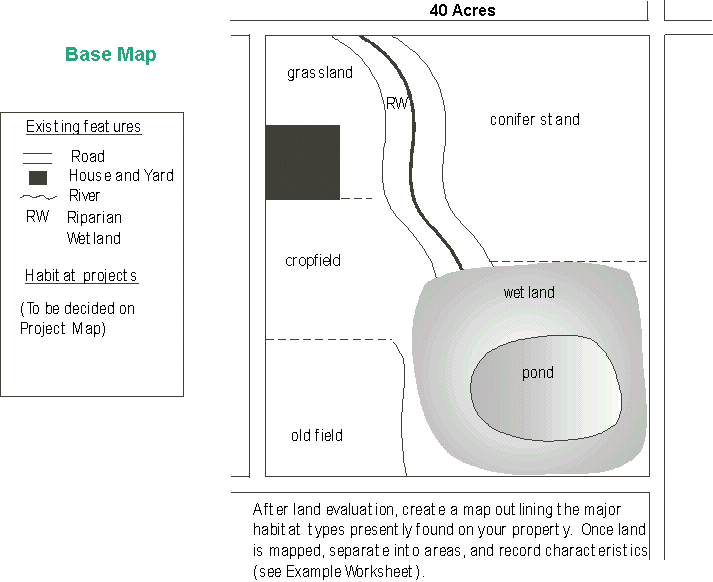
Creating a Base Map
A base map is a layout of your property that shows each type of habitat and any special features that need to be taken into consideration. It includes such components as forests, grasslands, wetlands, streams, lakes or ponds, shelterbelts, hills, drainage ditches, buildings, fencerows, logging roads, cultivated fields, and roadways. Also, highlight those features of special importance to wildlife: ground dens, dead trees, living trees with large cavities, bird feeders, nest boxes, mature nut trees, major travel lanes, and more. The base map provides the basis for your management projects, and will later be used in writing the management plan. Make sketches of your property as you increase your knowledge about it. It may be helpful in creating a base map to obtain aerial photos and topographic maps of your property. Aerial photos are available at your local USDA agency office. The more you learn, the easier it will be to focus on specific areas for habitat improvement.
| After land evaluation, create a base
map featuring the habitats present on your property. Outline any
special features such as den sites, bird feeders, travel lanes,
fencerows, etc. This map will serve as the base to the project map
created later in the planning process. |
Put Your Inventory Into Context
Keep in mind that everything is connected. The plants on your property, for example, can act as seed sources for your neighbor's land and vice versa. Animals using your site do not know the meaning of a property boundary. So, it is important to remember that the landscape around you determines what you can realistically expect to do on your property. And the reverse is also true: what management decisions you make on your land will affect the landscape around it. The chapter
Working with Neighbors gives more information.
In summary, it will help tremendously if you understand what plants and animals you can reasonably expect to flourish on your property before you set goals, write a plan, or begin to make management decisions. Working within the context of your land and surrounding landscapes will help you to create a successful wildlife management plan..
Last Revised: October 12, 1999
|


